India's Self-Reliance in Defense: The Leap of the NavIC Satellite Mission and Indigenous Navigation Technology
By reducing dependence on GPS, India has strengthened its security apparatus through the development of indigenous technology for military tanks, missiles, and navigation satellites.

The use of indigenous technology in the fields of space and ground navigation is taking a new turn for the Indian defense forces. The NVS-03 satellite launched into Earth's orbit by the Indian Space Research Organisation (ISRO) and the Inertial Navigation System (INS) manufactured at the Ordnance Factory, Chandigarh, are providing the Indian Army with new capabilities on the battlefield. Specifically, following the successful launch of the NVS-03 via the GSLV-F18 rocket, the capabilities of India's own domestic navigation system, 'NavIC', have seen a significant increase. According to an Amar Ujala research report, this development will allow the Indian military to obtain precise data during war and emergency situations without relying on any foreign systems.
On the other hand, the technical collaboration between Indian Optics Limited under the Ministry of Defence and France's Safran Electronics & Defense has led to the domestic manufacturing of the INS Sigma-30N at the Ordnance Factory, Chandigarh. According to the Amar Ujala report, following the memorandum of understanding signed on December 22, 2025, 24 INS units have been prepared so far, and the first batch has been sent to a state-of-the-art defense production unit located in Surat. Under this agreement, the Chandigarh factory will hold the exclusive rights to produce this system for the next 15 years, which will eliminate dependence on foreign imports.
Historical Background: The 1999 Kargil War and the Need for Indigenous Technology
The need for India to build an indigenous navigation system arose during the 1999 Kargil War. At that time, the Indian military needed to use the United States' Global Positioning System (GPS) to obtain precise data on the geographical location of the Kargil region, but the US refused to provide this data to Indian forces. At that time, Indian Air Force pilots had to fit standard commercial GPS devices into their cockpits to carry out administrative and combat operations and attack targets. Learning from this experience, the Government of India approved the plan to build its own indigenous navigation system in May 2006.
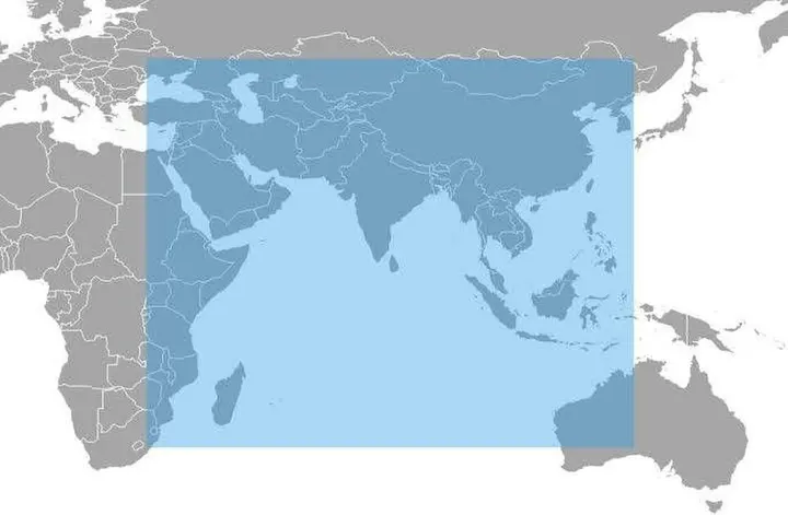
The project initiated by ISRO was initially named the Indian Regional Navigation Satellite System (IRNSS), which was later known as 'NavIC' (Navigation with Indian Constellation). The NavIC system provides highly accurate real-time positioning, velocity, and timing (PVT) services within India's main geographical boundary and an area of 1,500 kilometers around it. According to the plan, the goal is to expand this capability to 3,000 kilometers in the future, achieving a location accuracy of 10 to 20 meters and a time accuracy of 40 nanoseconds.
Operational Mechanism and Technical Framework of the NavIC System
Satellite-based navigation systems primarily provide two types of services: first, the Standard Positioning Service (SPS), which is open to ordinary citizens and is compatible with other Global Navigation Satellite Systems (GNSS); and second, the Restricted Service (RS), which is secured for military and authorized users through an encrypted link. These services operate on L1 (1575.42 MHz), L5 (1176.45 MHz), and S-band (2498.028 MHz) frequencies.
The most important key to a navigation satellite is the atomic clock housed within it. An atomic clock calculates even the smallest units of time with extreme precision, which is used to determine the distance between the satellite and a receiver on the ground. The first generation of IRNSS satellites contained Rubidium Space Clocks provided by a foreign company. However, as some atomic clocks developed technical faults over time, ISRO developed its own indigenous Rubidium atomic clock at the Space Applications Centre (SAC), Ahmedabad. These indigenous atomic clocks have been used in the new-generation NVS series satellites (such as NVS-01 and NVS-03), which has increased the lifespan of the satellites from 10 years to 12 years.
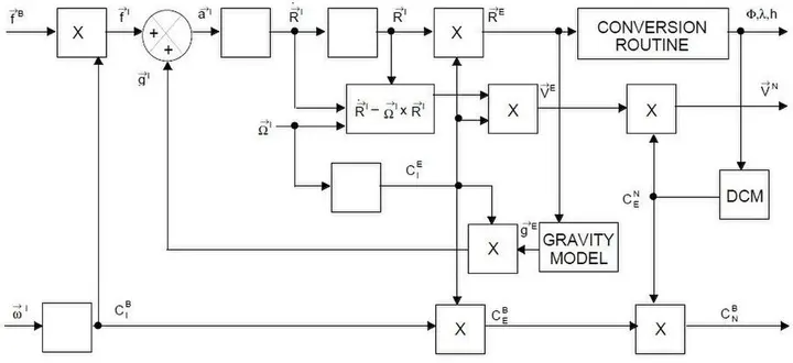
- 1. Initial Position SetupThe initial geographical location (latitude and longitude) of the tank or missile is entered when starting the system.
- 2. Motion and Rotation MeasurementThe internal accelerometer measures acceleration and the gyroscope continuously records angular rotation (tilt and direction).
- 3. Indigenous MicroprocessingThe vehicle's real-time velocity and direction are calculated by processing the measured data using Ajeet or similar local processors.
- 4. Precise Location OutputEven amidst satellite jamming, the system guides the missile or tank to its precise target.
Localization of military hardware and INS technology
Beyond satellite navigation in space, the Inertial Navigation System (INS) is extremely important for providing precise orientation to military tanks, artillery, and missiles on the ground. INS is a system that calculates the position, orientation, and velocity of a vehicle or missile using only its internal motion sensors (gyroscopes and accelerometers), without the need for satellite signals or any external radio signals. During wartime, when an enemy country jams satellite signals, the INS system proves to be a boon for the military.
The INS Sigma-30N system being prepared at the Ordnance Factory Chandigarh is being manufactured in India under a French technology transfer. Furthermore, the AJIT microprocessor developed by IIT Bombay and the navigation chipset manufactured by Accord Software under DRDO's Technology Development Fund provide indigenous time and location data to Indian military receivers. Global chip manufacturers like Qualcomm have also added support for NavIC L1 and L5 signals to their processors.
₹ કરોડ
Project cost, budget, and comparison
At the inception of the NavIC project, ISRO estimated a total cost of ₹1,420 crore. This included ₹300 crore for the ground segment, ₹150 crore per satellite, and ₹130 crore for each PSLV-XL rocket launch. However, due to additional replacement satellites and orbit correction missions, the total cost of the project increased to ₹2,246 crore (approximately 233 million dollars) as per the March 2017 report of the Comptroller and Auditor General (CAG).

Compared to global systems like America's GPS, Europe's Galileo, and Russia's GLONASS, India's NavIC system provides higher accuracy over the Indian subcontinent despite being regional. The United States Congress has also recognized NavIC as a navigation system of its allied nations under its National Defense Authorization Act 2020.
Future Plans and Challenges
The Government of India has made NavIC-based vehicle tracking mandatory for all commercial vehicles as per AIS 140 standards since 2019. Furthermore, plans have been formulated to use NavIC instead of GPS for reference of Indian Standard Time (IST) at the National Physical Laboratory (NPL). Although the failure of atomic clocks in some first-generation satellites caused partial service disruptions, this issue is being resolved through the launching of the NVS series undertaken by ISRO.
With indigenous navigation solutions, India is now becoming independent in the defense sector. In the battlefield, the combination of NavIC and INS to provide accurate location information for smart munitions, drones, and long-range missiles provides the Indian military with an unparalleled security shield. This technological revolution of India is truly realizing the 'Atmanirbhar Bharat' vision.